Top of Cinder Cone

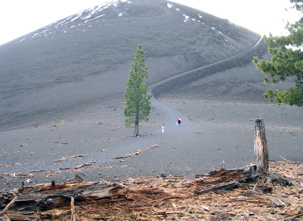
Cinder Cone itself is a 700-foot pile of dark, coarse sand piled into a classical cone-shaped volcanic mountain with a bowl-shaped crater on the top. A steep trail has been cut into the side so that you can climb to the top to enjoy the view and explore the crater.

Cinder Cone

The trek up the steep hill was tiring. While I stopped to rest, my kids had a great time making snowballs and throwing them down the steep hillside (and at each other).

Snowballs on cinder cone trail

When you reach the top, you can hike along two concentric crater rims. It was quite windy up there. The view of the Fantastic Lava Beds and Painted Dunes was impressive.

Lava flow and painted hills from top

The two wind-blown trees on the crater rim helped scientists determine the age of Cinder Cone and the time of the eruptions. Radiocarbon dating of trees killed by the lava flows show that the eruptions occurred about 1650, give or take 20 years.

In the photo below, the lake in the background is Snag Lake. The lake formed behind the lava beds when they flowed across and blocked Grassy Creek.

Wind-blown tree on top

As we descended Cinder Cone, a light snow began to fall. To speed the descent, we walked fast and placed each footstep heel-first hard into the coarse volcanic sand. Each foot would sink into the sand up to the ankles, so a lot of sand got into our shoes. We emptied our shoes when we reached the bottom of the hill.

I had a good time playing "kick the pine cone" with my daughter as we walked back through the forest to Butte Lake. The trail was downhill all the way back to the lake, so the pine cone would roll a long way with each kick.

For the story of the scientific investigation into the Cinder Cone eruption, see the United States Geological Survey's web site, How Old is Cinder Cone? (The PDF version of this document looks better, but takes longer to download.) For scrollable panoramic views of Cinder Cone, see the Virtual Guidebook to Mount Lassen - Cinder Cone.


Next: Bumpass Hell

©2005 Gray Chang