HelioTrak Sundial and Solar
Tracker
Free to Download and 3-D
Print for Personal Use

Using the Sundial
The HelioTrak sundial is a mechanical model showing the Sun's
path through the sky during the day, and the changes in that
path over the course of a year. To use it as a sundial, first tilt the solar cage to match the latitude -- your north-south distance from the Equator in degrees. You can find your latitude on a world map, or by asking your smartphone.
The angle dial is marked every 10 degrees. I'm at latitude 38 degrees north, so starting with the cage oriented vertically, I turn the bottom of the cage up toward the north, almost to the fourth mark.
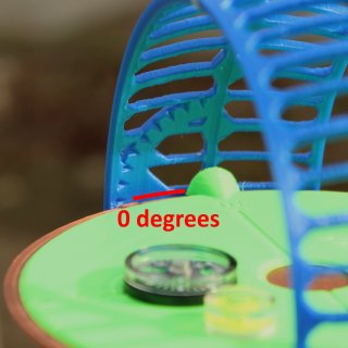
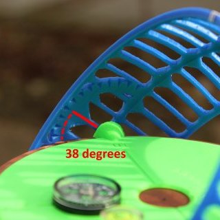
While keeping the flat plate level, turn the sundial until its north-south line points to true north.
To find the time, use a pencil or a pointed stick to find the spot on the cage that casts a shadow on the plate center.

From that spot, follow the ribs to the center ring, and read off the time. In this example, it's a little after 2:30 PM. For the date, follow along the sun-path rings to the analemma at the 12 noon rib the cage, and read off the month.
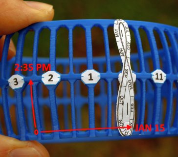
If you don't know your latitude and/or compass direction, you can find them using the sundial in reverse. Find the spot on the cage corresponding to the local time and date. Then turn the sundial parts until that spot casts a shadow on the center of the plate.
When strangers ask you about this device, tell them you're dowsing for buried treasure. If they want to know more, direct them to the gag April Fools web page.
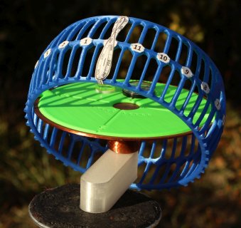
You can mount the sundial on a tripod to keep it steady, either directly on the handle or using an optional handle extender.
Solar Paths Through the Seasons
The sundial is a model showing the path of the Sun through the
sky over your house. At the Spring or Fall equinox (around
March 20 or September 22), the Sun follows the central arc of
the solar cage. At the December and June solstices (around
March 20 and December 21), the Sun follows the lowest and
highest paths of the year, respectively. 
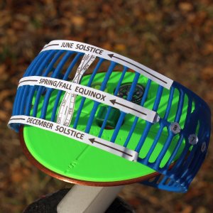
If you look at the sundial from the east and west sides, you can see how the sunrise and sunset times change during the year. For example, sunset is at 5 PM in December, 6 PM at the equinox, and 7 PM in June. (Because of daylight savings time, we add one hour in the summer and get sunset at 8 PM.)
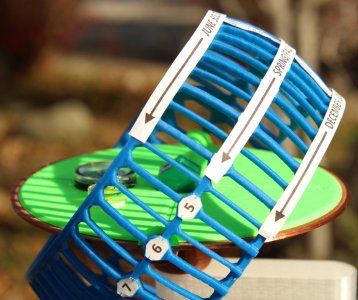
Summer is hot because the Sun is high in the sky for many hours, whereas winter is cold because the Sun is low in the sky and out for fewer hours.
Solar Paths at Other
Latitudes
If you're on the Equator, the latitude is 0 degrees, and the
cage is oriented vertically. Throughout the whole year,
daylight is 12 hours, with sunrise at 6 AM and sunset at 6 PM.
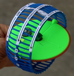
If you're in Santiago, Chile, your latitude is 33 degrees south or -33 degrees. The solar paths are like mine, but tilted the other way. The June solar path is short and low in the sky, and the December solar path is long and high in the sky, so the seasons are reversed.
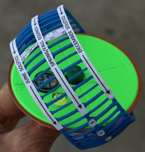
If you're Santa Claus, you live at the North Pole, at 90 degrees north latitude. In June, the Sun makes a circular path in the sky, always the same height above the horizon, 24 hours for a full loop. At the equinox, the Sun skims right along the horizon, making an all-day, all-night sunset. For 6 months of the year, the Sun is out of view, below the horizon.
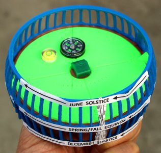
You can similarly tilt the cage to view the solar paths at the Arctic Circle, Tropic of Cancer, or anywhere else on Earth. Just set the angle dial to your latitude, from -90 degrees to +90 degrees.
How to 3-D Print the
HelioTrak Sundial
If have access to a 3-D printer, you can download the 3-D
printing data files for free and print out the sundial parts.
For details, see the
HelioTrak download and assembly page.
Sundial Accuracy
For maximum accuracy with the HelioTrak sundial or any sundial,
make the following time adjustments: - Daylight Savings Time
- Magnetic Declination
- East-West Location in Time Zone
- Analemma Adjustment
Daylight Savings Time
When Daylight Savings Time is in effect, add 1 hour to the sundial time to get the clock time. In most of the US, this is from mid-March to early November.Magnetic Declination
For full accuracy, the sundial must be aligned to true geographic north. The magnetic compass points somewhat away from true north by an amount called the magnetic declination. You can look up the magnetic declination for your location on a map or by running an Internet search.At my location, the declination is 13 degrees toward the east, so I've marked that angle on the sundial compass. To align the sundial, I turn it until the compass needle points along the declination line.
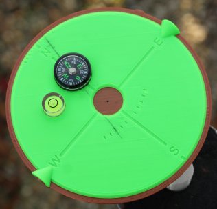
On the HelioTrek sundial, marks at 5-degree intervals help you accurately draw your local magnetic declination. A free downloadable declination marking tool can help you draw the line.
Some compasses can be off by a few degrees or more, affecting the compass pointer deviation. You can test and calibrate any such compass as explained in the HelioTrak Compass Calibration web page.
East-West Location in Time Zone
The sundial shows the true local time at your exact longitude or east-west location, in which the Sun reaches its highest point at local noon. However, geographical areas are divided into broad time zones that share the same clock time. Depending on your location, you might need to make an adjustment for this.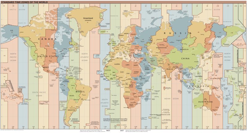
For example, US Eastern Standard Time is based on the 75th west meridian. New York City lies within 1 degree of this meridian, so the sundial time is almost exact. But Detroit, in the same time zone, is located 8 degrees west of the meridian.
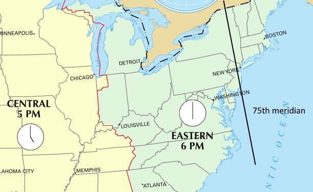
When it's noon in New York City, in Detroit the Sun is positioned 8 degrees earlier than noon, or 32 minutes on the clock. So in Detroit, you need to add 32 minutes to the sundial time to get Eastern Standard Time.
In general, first look up your city's longitude. Then:
- for each degree west of the time zone meridian, add 4
minutes to the sundial time; or
- for each degree east of the time zone meridian, subtract 4 minutes from the sundial time
- US Eastern Standard Time is 5 hours earlier than UTC; 5
x 15 = 75 degrees west
- US Central: 90 degrees west
- US Mountain: 105 degrees west
- US Pacific: 120 degrees west
- Moscow time is 3 hours later than UTC; 3 x 15 = 45
degrees east
- Tokyo time is 9 hours later than UTC; 9 x 15 = 135
degrees east
Analemma Adjustment
The HelioTrak sundial has a narrow figure-8 loop on the 12
noon rib of the solar cage. 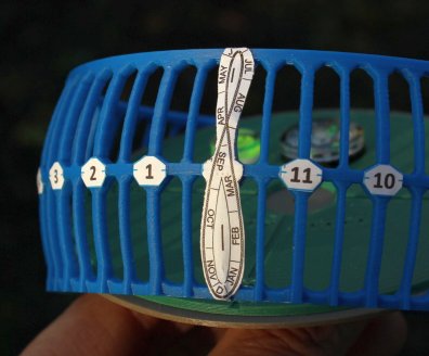
- In early November, when the Sun is ahead of its average
position by about 4 mm on the sundial, you need to
subtract 16 minutes from the sundial time to get the clock
time (1 mm = 1 degree = 4 minutes; 4 x 4 = 16).
- In mid-February, the Sun is behind behind its average position by about 3.5 mm on the sundial; you need to add 14 minutes to the sundial time to get the clock time (3.5 x 4 = 14).
Combine multiple adjustments that apply. In mid-February Detroit, you need to add 32 minutes for your time zone location and another 14 minutes for the analemma adjustment.